About microdrones
microdrones was founded in Germany in 2005, with the launch of groundbreaking unmanned aerial vehicles. As the pioneer of the professional quadcopter industry, microdrones has developed solutions based on reliable VTOL drones, with a heritage of German engineering and quality.
By integrating the most capable and dependable platform with the right payloads and dedicated processing, microdrones has implemented professional solutions in Europe, Asia, and North America. A global leader in commercial UAVs, microdrones offers local sales, training, and services centers across three continents, to serve customers around the world.
About mdAIRCRAFT
Whether your intent is to buy the best aircraft for your goal and add your own payload later, or to buy a complete solution with everything you need for a specific application, microdrones has you covered.
At the heart of all of our solutions are our industry-leading, German-engineered aircraft. Known for their stability and endurance in the face of tough challenges, more than 1,000 companies around the world trust microdrones UAVs to produce the best possible results and reliability for their client.
The microdrones fleet currently consists of the following three models:
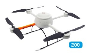
1. md4-200 - This competitively priced professional UAV is compact and lightweight yet, yet flies 20-25 minutes in less-than-ideal conditions. GIS professionals can cover 30 hectares in a flight, which is a good entry capability and enough for many users.
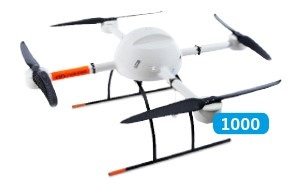
2. md4-1000 - This best-selling UAV is a customer favorite because it offers the best real-world flight times on the market - up to 45 minutes with heavier payload - and stands up to a wide range of harsh environmental conditions.
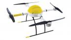
3. md4-3000 – The newly released md4-3000 is the most advanced microdrones aircraft and can carry a large payload between 7 and 15 pounds. Perfect for heavy LIDAR sensors, professional mapping grade cameras, multiple sensors, and other heavy equipment, the release of md4-3000 represents a revolution in payload flexibility.
About mdSOLUTIONS
microdrones mdMapper packages combine our state-of-the-art UAVs with payloads that were specifically designed to meet the needs of those who use them for mapping applications like surveying, inspection, photogrammetry, cartography, and precision agriculture.
Here is a brief overview of each, followed by links to fully explore each offering:
mdMapper200: Compact but robust, the md4-200 aircraft at the heart of this solution is lightweight and easy to transport yet tough enough to stand up to rough weather and daily use. mdMapper200 is a reliable, professional solution that allows surveyors to map up to 30 hectares (74 acres) in one flight. It is integrated with a lightweight 20.1 megapixel camera and Nadir mount. www.microdrones.com/mdmapper200
mdMapper1000: Featuring the microdrones md4-1000 to cover more area per flight, users enjoy the longest flying time (30-45 minutes, depending on conditions) and stability on the market, as well as resistance to rough winds, harsh weather, hot temperatures, high voltage, and strong magnetic fields. It is integrated with a 24 megapixel camera and Nadir mount. www.microdrones.com/mdmapper1000
mdMapper 1000DG: Direct georeferencing technology sets a new standard of efficiency. With mdMapper1000DG, surveyors achieve the highest level of data accuracy possible using fewer ground control points or no ground control points at all and less overlap. Cover up to 90 hectares (223 acres) in one flight. It is integrated with a 42.4 megapixel camera and Nadir mount. www.microdrones.com/mdmapper1000dg
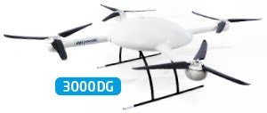
mdMapper 30000DG: This UAV can fly quicker, reach higher, and carry more. With a flight time up to 45 minutes, a payload of 3,000- 7,000 grams (6.5 - 15 pounds), this solution opens up an entire new world of flexibility and opportunity. It is integrated with a true medium-format camera with up to 100 megapixel performance, direct georeferencing technology and a Nadir mount. www.microdrones.com/mdmapper3000dg
Optional Accessory Kits: Complementing the above packages are optional accessory kits that help professionals broaden their capabilities on site, or to expand their services to serve new markets. www.microdrones.com/mdmapper-accessories
+m (multi-spectral imaging): captures five spectral bands for precision agriculture applications
+t (thermal mapping): captures thermal data to detect heat issues in agriculture, environment, solar panels, or infrastructure inspection applications
+i (inspection feature): transforms your mdMapper1000 into a powerful visual inspection tool for buildings and infrastructure
Want to learn more?
Visit us at our website: www.microdrones.com
Or contact a microdrones UAV expert to discuss what UAV solutions will be most profitable and productive for your business. Call 1 866 874-3566 or e-mail info@microdrones.com.